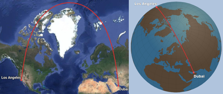
Great Circle Map is a tool for visualizing flight routes and calculating the distance between airports. A great circle path (also known as a geodesic path) is the shortest possible route between two points on the surface of earth or any other sphere. The map uses the Mercator projection by default. On this type of map, great circle paths tend to look curved even though they are in fact straight. As an alternative, the website also features a 3D globe view which doesn’t have that problem.
Projecting a 3-dimensional sphere onto a 2-dimensional screen always creates distortions. Most world maps use the Mercator projection or something similar. These projections tend to have large distortions around the polar regions. Distances look bigger than they really are near the poles, and relatively smaller around the equator. People tend to be particularly confused by how the shortest route between two cities like Dubai and Los Angeles goes via the north pole, despite the fact that both of these cities are situated pretty far south. It makes a lot more sense when you look at an orthographic projection.
The distances calculated are the shortest possible distances. However, airlines often don’t follow the shortest route exactly for a variety of reasons. Airspace reserved for military purposes and areas of conflict for example. The earth is not a perfect sphere, which is taken into account in the distance calculations. It is best approximated by an ellipsoid which is widest around the equator.
If you found a bug or have a suggestion, please contact me at [email protected] or file an issue on Github.
- Install Node.js 8 (newer versions will not work)
- Run
npm run buildin the project directory - Run
node server - Open the browser at 127.0.0.1:3000
If you plan to host this on your own domain you have to set up your own Google Maps API key (read more here)
Airport data comes from the openflights.org airport database.
